Tuesday, December 13, 2016

December 13, 2016 Mile 262

We finally made it back to Mile 262 a few hours after the King Tide of 10 feet. Lots of junk either washed up on the beach or, more likely, left there by people. We hauled off lots but could not begin to get it all. I reported the mess on the Cape Kiwanda State Natural Area, Oregon State Parks & Recreation website.

The area was virtually deserted when we arrived. Quite a contrast to summer time. One car with people and a dog arrived before Johnny walked back. I went over the dune to look for Black Oystercatchers so did not even see that car. But there were lots of human and dog footprints and lots of car tracks.

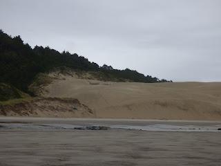
Looking north from McPhillips Park

Looking south from McPhillips Park (notice car tracks)

lots of kelp on the beach

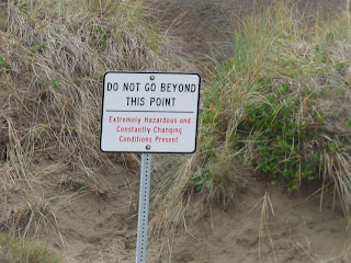
first time I've seen these signs

a fairly new eroded area and landslide

a refrigerator casing

the green stuff is a natural seaweed but so tangled together that it has all sorts of plastic debris trapped inside

One of two dead birds we saw. This one is a white-winged Scoter. The other was a Western Grebe

This is a dead and partly eaten marine mammal of some sort... seal or sea lion

The dune keeps moving, making signage difficult.


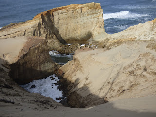
I had not noticed this cavity at the north end of the dune before

It is an eroded hole at the edge of the dune. Will be interesting to see what it looks like next time.

The sea stack is becoming more and more eroded by waves

looking southwest to the end of mile 262

The cliff is becoming steeper and steeper

This sign is at the base of the cliff pictured above

You can tell by the tracks leading past the sign that it is being ignored


Here is the sign and cliff from another angle

Looking north toward Cape Lookout from the dune
The resident Peregrine called and flew from his usual area and two Black Oystercatchers were visible. No rain or wind while we were there and mid 40s... a pleasant December day on the coast.

Thursday, July 7, 2016

July 7, 2016, Mile 262

At a minus tide today, the beach was completely changed from anything we have seen before. Sand has been swept away from the dune and the beach, leaving exposed lava flows. The changes are so dramatic I took a zillion photos and will post many of them here.

Colorful signs now mark beach sites so rescue crews can find people more easily.

These offshore rock outcroppings must only appear at a minus tide as we had never seen them before.

Sand is gone from much of the beach leaving a rocky bottom.

A beached and broken crab pot

The dune is now a vertical cliff to the beach

The Cape and Haystack Rock in the distance


It's difficult to see in this photo but there were zillions of tiny creatures darting around and attaching to this underwater rock in a tide pool isolated from the ocean... for now. Our CoastWatch volunteer coordinator, Fawn Custer, told me these are a type of Mysid shrimp: Bermudamysis speluncola; Opossum shrimp


The "no vehicles beyond this point" signs are fighting a losing battle now that the ocean has receded so far from the dune, or rather has stolen so much sand that the dune is now way back from the ocean.

Once isolated by water, this "castle" formation is now accessible from the rocky shore.

And 3 people with their 2 dogs were climbing all over it.

This is "my" mile of Oregon beach, looking north. Cape Lookout is way off in the distance.

The cape is being eroded by the relentless ocean

"my" mile looking north again across the exposed rocks

photo from same spot as above, looking west


The dune now has a sheer drop to the beach


This gull was feasting on a dead crab


It was beautiful weather, cloudy and warm. It started to sprinkle just as I left.


The resident Peregrine Falcon kept watch the entire time I walked his beach.

Tuesday, May 10, 2016

May 7, 2016 Mile 262

I hiked Mile 262 from McKillips Park at 4:20 in order to arrive at my north OP for Cape Kiwanda to survey Brown Pelicans from 5-7 p.m. I had dropped Johnny off at the Cape parking lot and he hiked up to our south OP to watch for Pelicans from there.

I took a few photos of the eroding cliff that I have photographed each time plus the rocky beach now that the ocean has washed the sand off and exposed lots of rocks. My camera quit working so I looked in my camera case for the spare battery... and discovered I'd left it at home in the battery charger. So no more photos.


The dune on this north side now has a steep cliff to beach instead of a gradual drop.


This was Mother's Day weekend and there were 11 cars on the beach in allowed areas, 2 beyond the allowed areas but they could not have known that because the signs saying no vehicles beyond this point were completely buried in sand. I'll go back and take more photos another time.

I climbed the dune and watched the Peregrines, a pair of Black Oystercatchers, whales, and finally several groups of from 1-3 pelicans each for a total of 10 birds. Some were flying northward and some southward.

I left at 7 and walked back to McPhillips Park.


Thursday, February 11, 2016

February 9, 2016 Mile 262

We hiked from McKillip's Park again, south to Cape Kiwanda. The access road had been cleared of debris, although much of it was still on the edges of the road and a few big pieces were still on the beach.


Looking north from the access road, the rock outcropping in the distance had birds perched on it.


 Zoomed up in the camera, they morphed into 17 Surfbirds.


Walking south, we found erosion of the bank everywhere. At the blocked-off former trail which was badly eroded, a pile of debris had been piled at the foot, presumably to stop the ocean from continuing to undermine the bank.


But the bank is being undercut everywhere from McKillips Park to the dune.


The monolith/cliff at the west side of Cape Kiwanda may be beginning to crack on the left side above the second tunnel. Haystack Rock is the big Sea Stack on the right side of the photo below.


This smaller rock, which I call Castle Rock, is just off the Cape, northwest of the cliff/monolith seen behind it here.

The two signs saying motor vehicles prohibited beyond this point are still standing, but on steep ground now.


Below photo is looking north toward Cape Lookout at about half an hour before high tide. The signs are in the middle of the photo in the distance.

Photo below taken a same point looking west along side of cape. Water cut left middle of photo now goes way up the cliff.


On this day, I climbed the north end of the dune as I'm not sure exactly where Mile 262 officially ends. Here is the monolith from on top with the two tunnels.


Same monolith/cliff from farther south with Haystack Rock in the distance and the fjord (or whatever it is called) between Cape Kiwanda and cliff.


Also from that point I took a photo, looking northeast, of the houses that sit high above the Mile 262 beach.

These houses are perched very close to the north end of the dune, which you can see in the foreground of the photo below.

The photo below was taken farther south, looking toward the cliff/monolith and the fjord with an ever-widening cut below where I'm standing. It is difficult to see the huge cave on the left side of this photo where water is cutting a channel under the dune.


So I lightened it here to hopefully make it visible.

It is also difficult to show how steep the north side of the highest point of the dune now is, with many fallen dead trees tumbling down toward the hole pictured in the photo above.

 Here is a shot looking up at the top of the dune with the steep drop off on the north side heading down to that chasm. This is much changed since my last visit during Black Oystercatcher monitoring season last summer.


I hiked on over to the south side of the dune and found the erosion there much worse as well. This is looking south with the water spout area to the right out of the photo. I didn't have the stomach for taking photos of all the people down by the water spouts trying to take photos of the water shooting out of the cracks. At high tide. Good grief.

Below is the extent of the eroded channel now, with the fence partially collapsed as the dune moves down toward the sea.

It will be interesting to see where the cape eventually splits off from the mainland... so many fingers of the ocean are working their way inward from so many directions now.